ITOGON, Benguet is more popularly known as the “gold haven” in the Region. With the mineral rich land and mountains oozing colors of crystal white to yellows to rich terra cotas and golds, rising from ordinary and semi-arid landscape. Driving through the now completely paved roads to the area, visitors get a glimpse of the ruins of once prosperous minesites that closed shop a few years back when the rich ores were depleted and and gone to muck. Lakes of granite-gray tillings still spread over some views.
ITOGON bespeaks of a mining town. The present town site was once a wilderness sturdy looking pine trees and green vegetation grew luxuriantly along the streams, where cool, fresh and clear water gleamed all day. Wild deer and boars roamed undisturbed while a good variety of birds sung melodies on branches of trees to the rippling waters where eels and other kinds of fish abound.
On the eastern side is the community of Tinongdan, Tuding on the western side and Acupan on the southern side, all inhabited by small groups of Ibalois. Farther north, along the source of the Agno River in Pasdong is another Inibaloi community known as Bokod and Kabayan. The inhabitants of said places obtain their simple living by planting root crops such as gabi and camote. Their meat requirement was easily met through hunting around. They lived peacefully with each other for they respected and followed the advice and guidance of their headmen who usually was the oldest in the group.
In Pasdong lived a loving couple named Nogal and Katuray. A baby boy was born out of their love life, but unfortunately, the couple died early leaving the baby an orphan. Kiampas, a sympathetic woman took him to her relatives in Daclan. The boy grew into a respectable man named Dominguez. He married Bacjot, the daughter of old man Tohto, a skillful hunter from Tuding. It was Tohto and his son-in-law Dominguez who discovered the gold nuggets while hunting into wilderness in a place called Antamok. The discovery became known to other natives living nearby and soon joined them for the purpose of gold mining. Because of constant hunting by the natives of Antamok, game was depleted. Dominguez was forced to explore in search of good hunting grounds. On the east of Antamok, he decided to build a shack on higher level while the lower area was used as a farm. The river also provided a good place for panning gold. The place came to be known as “Balingway”.
About three (3) kilometers away from Balingway is a place where an old man named Codeng lived. When the Spanish Government was established in Benguet, old Codeng was appointed to head Balingway where Captain Codeng reports regularly to the Spanish officials. In recognition of his deed, the Spanish officials named the place where Captain Codeng lived, ITOGON.
CHRONOLOGY OF ITOGON HISTORY
(Researched, compiled and edited by Prof. Morr Tadeo Pungayan, Ph.D.)
PRE-HISPANIC ITOGON
This period and earlier are characterized with narrations of warriors, family sagas, and Legends. From the Uma-umats, Bahdiws, and sacred songs, are learned for instance that the villagers followed their family heads who instituted arranged marriages to forge defense alliances; others of like import.
There were too the frequent narrations of “picking up” or “washing-gold” at Akkupan and other rich “finds” in el pais de los Ygollotes; so much so, that such “nose for gold” and later, the temptation for conquest, beset the Spanish authorities.
Three times, the conquistadores came to Itogon to enforce their “Royal right”, to wit: in 1620, Captain Garcia Aldana y Cabrera arrived at Boo (Bua); in 1623, Sgt. Maj. Antonio Carreño de Valdes came to the (now) Antamok minefields; and in 1624, Don Alonzo Martin Quirante tried in vain to exert more force but: all three of them were unable to subdue the recalcitrant stances of the then (Itogon) Ygollotes, and those Spaniards had to leave frustrated and gold-empty.
HISPANIC PERIOD (1892-1898)
This Regime starts with the appointment of Codeng (or Ko-deng) of Itokhon – now Piket, Poblacion as Capitan del Pueblo Itogon. In succession came Shomingkis (one name); then, Kirey or Guirey; then, Baldomero Maingpes. The Period from Codeng to Maingpes, is listed in the Municipal Hall as: 1892-1899.
AMERICAN REGIME (1898-1945)
The period is remembered by the arrival of a party of “less than 10 or so” insurrectors at Sitio Lucbuban. Although these convinced the villagers they came in peace, a messengered-information revealed the insurrectors were being pursued by American troops. Later, these troops – mostly of the Afro-American contingent, made tent camps at Balingway – now Itogon Central.
Mining came with the Americans.
This regime marked the coming of the missionaries who built churches and schools.
It also marked the exposure of the Igorots to other cultures.
The construction of the road systems facilitated various trading.
In a pivotal moment, the United States Philippine Commission Act No. 48, enacted on November 22, 1900, provided for the establishment of local civil governments in the townships of the Province of Benguet. This legislative initiative played a crucial role in shaping the administrative and civic framework of Itogon.
JAPANESE & JUST AFTER (1941-1945)
When World War II broke out in 1941, Itogon – like the rest of the Country, was plunged into deep fear and terror.
In April of 1942, some escapes of the infamous Death March – among them the Itogonian Antonio F. Carantes, organized the 66th Infantry, USAFIP-NL at Dalupirip, Itogon.
At a later part of this Regime, Itogon suffered two subsequent “Executions” – that of the Municipal Mayor and his Chief of Police. A witness and still a survivor Ina Patricia T. Canite relates: “our hearts were deepest hurt those times”.
Two incidents exemplify the Itogon participation in responding against that War: 1) the Skirmish at Supang – where elements of the 66th Infantry attacked a Japanese tank-guided column, and 2) the Encounter at Bangen Twinriver – involving Japanese troops versus civilian volunteers; one in the lead was non-regular Gavino Galunza.
During said War, Itogon was filled with cases of Bacwets or evacuees, suffering, sickness-even deaths; so long and gloomy if all told.
MODERN AND CONTEMPORARY PERIOD (1946-PRESENT)
On May 15, 1951, Republic Act No. 616 was approved to convert the Municipal District of Itogon, Sub-Province of Benguet, Mountain Province, into a regular Municipality which is known today as the Municipality of Itogon.
In the early 1950’s, Itogon citizens – especially those in Northeastern Binga and Debcow, the Dongbaan of the North and South Riverbank Ibalois, were gripped with fear of an impending dam, as at those times, the construction of one at Ambuklao, Bokod, was on-going.
In 1954, it happened: bulldozers were scarring the Guissit Mountains to make way for the Binga Dam. In 1956, actual work on the dam-site commenced. In 1960, the NPC closed the gates at the spillway to mark the trapping – second time of the waters of the Agno River; this time at Binga, a territory of Itogon Municipality.
In 1962, Dalupirip citizens defended themselves against an “armed group”. All 15 or so of said group died in that battle. One from the Dalupirip side – Anas Walis, perished in that Defense.
Twenty years after – in 1982, another “armed group” were stopped at Tihgwang by Dalupirip men. There were no reported casualties on both sides, but it is said the armed group “scattered themselves in-retreat towards the South, and never came back again”.
Meanwhile, in 1972 when Martial Law was declared nation-wide, Itogon enjoyed relative peace, and after 1986 Edsa, Itogon was “co-joyous” with the rest of the Nation.
In 1986, a plane crashed at Mt. Ugu – in Tinongdan.
In 1987, with the coming of the O-I-Cs, Politics in Itogon was re-invigorated.
In July 16, 1990, the killer Quake left evidences of its fury as well in Itogon: roadsides, airlifts, suffering, even deaths were common.
The fever “to rise” from the devastation brought about the emphases on infrastructure projects; Itogon was not spared from that fever.
In 1995, the debate for the damming of downstream San Roque ensued. It took 4 years and a half of tedious consultation before the project was endorsed.
But in 1999, the San Roque Dam Construction commenced, and it was completed in 2002.
In 2005, the Dongba ni Kabajo – an eversince Sports of the Itogonians, was revived by Maksil in Ibaloi or Makniba in Barangays Dalupirip, Tinongdan and Poblacion – sometimes fondly accronymed as TIDAP.
In 2006, private Swimming pools mushroomed at 1300 Level, Poblacion, drawing tourists and enthusiast alike – both foreign and local.
In 2008, NAPOCOR Binga and Ambuklao privatized – and the SN Aboitiz took over, issues of unpaid claims, misprioritizations, employment opportunities, etc., came again to the fore.
Meanwhile, a yearly Mt. Ugo Climb is institutionalized as a tourism activity of the municipality. Recently, the municipality received the whole of fame pearl award.
Revival attempts too for the kintoman red rice made by the municipal government in the pilot areas of the TIDAP barangays. The trust of the municipality now is organic agriculture.
In nearly all Itogon barangays at present time, small-scale mining is a flourishing industry, accented by the recent completion of the Baguio-Bua-Itogon-Dalupirip National Road.
TOPOGRAPHY AND SLOPE


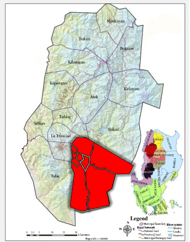
Itogon is at the southern end of the Central Cordillera Mountain Range and forms into an irregularly shaped area oriented along the north-south direction. It is generally mountainous in terrain with deep valleys and steep slopes. Elevation varies from 2,025 meters above sea level, particularly in Mt. Yabaong of Barangay Tinongdan in northeast, to 100 meters particularly in the areas approaching San Manuel in Pangasinan at the southern tip. Running from the south in the northern and eastern direction, the elevation rises to the thousand meters mark, the highest spot elevation of which is at 2,150 meters above sea level found at Mt. Ugo on the eastern portion adjoining the province of Nueva Vizcaya. In terms of slope percentages and land area covered per slope category, above 50% class slope makes up 74.6% of the municipality or an area of 37,150.8 hectares.
CHIEF EXECUTIVES OF ITOGON
- Capitan Codeng de Itokon – 1882-1893
- Capitan Schuminkis – 1894-1895
- Capitan Kirey – 1896-1897
- Capitan Baldomero Maingpis – 1898-1899
- President Jose Smith Fianza – 1900-1901
- President Joaquin Opiles – 1914
- President Benaldo Docayag – 1920-1921
- President Ikpao Islao – 1922-1925
- President Luis Depaclos – 1930-1931
- President Mariano Fianza – 1932-1933
- President Balegan – 1934-1935
- President Lauro Carantes – 1936-1937
- Mayor Paran Docayag – 1938-1939
- Mayor Cesario Fianza – 1940-1942
- Mayor Gregorio Camantiles – 1945-1946
- Mayor Lazaro Akitan – 1947-1949
- Mayor Placido F. Carantes – 1950-1955
- Mayor Pedro Ngaosi – 1956-1959
- Mayor Laurencio C. Fianza – 1960-1967
- Mayor Placido F. Carantes – 1968-1971
- Mayor Alejo M. Pacalso – 1972-1981
- Mayor Walter R. Carantes – 1981-1986
- OIC Mayor Alfonso L. Fianza – 1986-1987
- OIC Mayor George Api-it – 1988
- Mayor Alfonso L. Fianza – 1989-1992
- Mayor Crescencio C. Pacalso – 1992-2001
- Mayor Mario W. Godio – 2001-2010
- Mayor Oscar M. Camantiles – 2010-2013
- Mayor Victorio T. Palangdan – 2013-2022
- Mayor Bernard S. Waclin – 2022-Present


